Approach Planning
12 March 2016 | 550 miles NNE Cape Horn
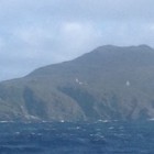
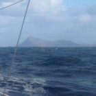
As a glider pilot it is impressed upon us the importance of planning the approach. A good approach leads to a good landing and hence the analogy as a yachtsman a good approach goes much of the way towards making a good landfall. It is with this in mind I will outline my intentions over the next week or so to pass close by Cape Horn. With the preponderance of a West component in all the winds at this latitude the intention is to pass through the Straits of Lemaire which separates Staten Island from the main bulk of the land to the West, the very large island of Tierra del Fuego shared between Chile and Argentina and separated from the South American continent by the Straits of Magellan. The reason for passing through this 15 mile wide Strait is should very strong West or South West winds spring up I can heave too in the relatively calmer waters in the lee of Staten Island and away from the permanent East going current of around a knot to the South. Should the winds be more favourable from the North West it cuts off 40 odd miles of Westerly component on the run to the Horn, a distance of about 100 miles. Just to digress we had the great good fortune on our last cruise through these waters of meeting up on Alexander Selkirk Island with the Chilean Navy Fleet undergoing their annual cruise and became honoured guests of the Navy Yacht Club right in the centre of Valparaiso. Through this we also became guests of the Navy in Punta Arenas and Puerto Williams. We were also presented with a handsome portfolio of the very detailed charts of the Southern Channels and their many excellent anchorages. But the most important thing we received from these sources was the absolute importance when choosing an anchorage of allowing for a sudden change of wind from any direction which can reach hurricane force within the hour. Graphic tales of yachts smashed up on lee shores reinforced this advice. That was forty years ago but the warnings are still fresh in the mind, so it is the intention to avoid if at all possible anchoring in these waters. Just as a reminder a few minutes ago passed a couple of quite big patches of kelp which make terrible holding ground so the done thing is to motor around and find a patch of sand, a luxury denied on this occasion under the Rules. With the advantage of GPS with excellent digital charts plus the 16 mile radar and regular detailed weather forecasts this should alleviate the need to anchor. The outliers to the Northwest of the Falkland Islands lie directly on track but can be easily avoided. Sailing along smoothly under perfect conditions with brilliant blue skies and bright sunshine and a favourable forecast for the next few days augers well for the next part of the adventure.