BANGORANG!
28 July 2016
27 July 2016
26 July 2016 | 400 miles West of Washington
24 July 2016 | On top of the High
23 July 2016
22 July 2016 | ~800 miles west of Washington
21 July 2016
20 July 2016
19 July 2016 | Somewhere parallel to Oregon
18 July 2016 | 1030.7 hPa
17 July 2016
17 July 2016
16 July 2016
15 July 2016
14 July 2016
13 July 2016 | 450 miles North of Hawaii
12 July 2016 | 300 miles north of Oahu
11 July 2016
09 July 2016 | KoOlina Marina, Oahu
19 June 2016 | Honolulu
Taking a break from Tacoma summer
15 September 2017 | Tacoma
Colin Gegg
After our successful cruise around Vancouver Island in June/July we cleaned up the boat and headed to SoCal for a couple weeks then off to a European river cruise from Amsterdam to Zurich. Not quite the same as sailing Bangorang, but quite interesting and restful. Now back in the PNW we are hoping to try a late summer cruise to the South Sound.
Beware Navionics Charts ARE Accurate, but your GPS may not be…
17 July 2017
Colin
Every so often someone hits a reef, or a rock or the beach and the first thing I read is that the Navionics Charting software was somehow at fault. Usually, the chartplotter showed the boat in open water right before hitting bottom. Alternatively, I've seen claims that Navionics software placed the boat miles inland while safely anchored in a cove somewhere. I suggest that it may not be the Navionics charting, but rather the GPS input that is off course.
In our Pacific Circuit cruise we sailed nearly 30k miles There and Back Again using Navionics charting software on a pair of networked Raymarine chartplotters (e7d and e125 series) with an external pole mount GPS antenna. We have crisscrossed the largest ocean on the planet and frequently navigated through scattered reefs, narrow channels and passages so tight we had little more than a boat length on either side. Wherever we went we'd load the regional Navionics charts and over 5 yrs they have ALWAYS plotted our position exactly as we saw it to be... until one time last summer...
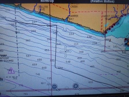
We were motorsailing SE along the south end of Vancouver Island, BC finishing a circumnavigation of the island. The weather was clear, winds light and current favorable. While closer to Vancouver Island, we could easily see across the Strait of Juan de Fuca to the WA side. Over a couple of hrs our chart plotter showed us slowly veering north as I made course corrections to the south. Eventually, the plotter had us 0.5 mile off and heading for the beach, when in fact we were miles from shore and headed for Port Angeles, WA. I tried rebooting the chartplotter a couple of times, but always it returned to the northerly course for the beach. Finally, I switched the chartplotter off the external GPS antenna and switched on the redundant internal GPS antenna. Instantly our position jumped 3 miles to the south and our new course now matched the boat heading (see photo). I was able to reproduce the faulty GPS coordinates and track just by switching back to the external GPS antenna. Anyway, we finished the cruise on the internal GPS antenna and back in Tacoma I replaced the external antenna. Once again, the Navionics charts were spot on! Although it failed, the old GPS antenna had performed admirably throughout our cruise, sometimes running 3 weeks straight and was retired with honor.
While I still love the GPS/chartplotter technology, I've once again learned to get my head out of the boat and look around. Also, embracing a belts and suspenders approach to redundant technology could prove a game saver.
In our Pacific Circuit cruise we sailed nearly 30k miles There and Back Again using Navionics charting software on a pair of networked Raymarine chartplotters (e7d and e125 series) with an external pole mount GPS antenna. We have crisscrossed the largest ocean on the planet and frequently navigated through scattered reefs, narrow channels and passages so tight we had little more than a boat length on either side. Wherever we went we'd load the regional Navionics charts and over 5 yrs they have ALWAYS plotted our position exactly as we saw it to be... until one time last summer...
We were motorsailing SE along the south end of Vancouver Island, BC finishing a circumnavigation of the island. The weather was clear, winds light and current favorable. While closer to Vancouver Island, we could easily see across the Strait of Juan de Fuca to the WA side. Over a couple of hrs our chart plotter showed us slowly veering north as I made course corrections to the south. Eventually, the plotter had us 0.5 mile off and heading for the beach, when in fact we were miles from shore and headed for Port Angeles, WA. I tried rebooting the chartplotter a couple of times, but always it returned to the northerly course for the beach. Finally, I switched the chartplotter off the external GPS antenna and switched on the redundant internal GPS antenna. Instantly our position jumped 3 miles to the south and our new course now matched the boat heading (see photo). I was able to reproduce the faulty GPS coordinates and track just by switching back to the external GPS antenna. Anyway, we finished the cruise on the internal GPS antenna and back in Tacoma I replaced the external antenna. Once again, the Navionics charts were spot on! Although it failed, the old GPS antenna had performed admirably throughout our cruise, sometimes running 3 weeks straight and was retired with honor.
While I still love the GPS/chartplotter technology, I've once again learned to get my head out of the boat and look around. Also, embracing a belts and suspenders approach to redundant technology could prove a game saver.
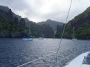
The Broken Group
13 July 2017
Stunning, fully enclosed anchorage between Dodd and Turtle islands. Very peaceful until big powerboat unleashed a couple of jet skis on us. Somehow they thought we'd enjoy them tearing circles around our boat. Finally I lost my temper, hit them with the air horn and politely asked them to get the helll outta the anchorage.
Tofino
12 July 2017
What a fun town! Kind of a funky little hippy/tourist town. Lott a great places to eat and nice walks
Winter Harbor/North Harbor
26 June 2017 | West Vancouver Island
Colin
Winter Harbor is a small fish camp/resort community with about 20 full time residents. In summer, a lot of sport fishermen come to town. We were a bit early, so it was still pretty quiet. There is a 3-plank boardwalk that runs the entire shoreline and makes for a nice scenic walk. It turns out the boardwalk is under the jurisdiction of the Provincial Highway Dept. and they maintain it. There is also a general store, fuel dock and burger shack and that’s about it. Still, the people were quite nice and directed us to a local hike through the pristine forest, where we saw a massive old-growth cedar.
There are many eagles here and a huge population of sea otters. I counted several rafts of at least 20 otters each, right next to the boat one morning. A local guy told me they relocated a few dozen from Alaska right after the Exxon-Valdez oil spill to save them and they have repopulated this coastline, with the last census at over 3000 otters. Great for the sea otters, but kinda hard on the crab fishermen…
There are many eagles here and a huge population of sea otters. I counted several rafts of at least 20 otters each, right next to the boat one morning. A local guy told me they relocated a few dozen from Alaska right after the Exxon-Valdez oil spill to save them and they have repopulated this coastline, with the last census at over 3000 otters. Great for the sea otters, but kinda hard on the crab fishermen…
Bull Harbor/Cape Scott
24 June 2017 | North Vancouver Island
Colin
Our next anchorage in Bull Harbor on Hope Island was the furthest point north of our Vancouver Island circumnavigation. This is a well-protected cove at the end of a narrow ziggityzag channel lined with rock faced cliffs. Inside is a good anchorage with a small (10-20 peeps) aboriginal village. That evening a couple came out in a rowboat to ask for $15 anchorage fee and another $5/head to go ashore. Bull Harbor is where most boats wait for a good weather window to cross Nawitti Bar and round Cape Scott. Both of these patches of water can be very challenging in the wrong conditions. Local knowledge gleaned from the cruiser’s guides and other boaters we spoke with, recommends going round Tamil Banks close to the shore to avoid Nawitti Bar altogether, riding an ebb tide out to the point, then standing off Cape Scott at least 3 miles to avoid the inshore tidal rips. All of which we followed, but as luck would have it, we had a very calm day and we motored around Cape Scott and down to Winter Harbor without drama. Probably coulda run the shorter course. We did see a lot of sea otters around Cape Scott, which was pretty cool.
| Vessel Name: | Bangorang |
| Hailing Port: | Ventura, CA |
| Crew: | Colin, Wendy and Skid |
| Extra: | Urban Dictionary: Bangorang - The word from the film "Hook" meaning, basically, awesome! |
Bangorang's Photos - Sea of Cortez


 - santa Rosalia")


 adobe building")


 |
Who: Colin, Wendy and Skid
Port: Ventura, CA
Gallery